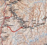
D-2: My trek's routes
Here are the region in the tajik's Pamirs I have planned to visit.
 * Lake Yashil Kul

* From the Sakhdara valley to the Panj Valley
 * Dasht - Vrang
 * Lake Yashil Kul
The lake Yashil Kul is situated a few kilometers North of the Pamir Highway, between Khorog and Murghab, at the altitude of 3700m. Depending on the transport I'll find, I will start my trek from Alichur or Bulunkul and follow the trail at the northern shore of the lake before going down the Gunt valley to Batchor. I plan to trek during 3-4 days, depending from where I start. The path is easy, since the highest altitude seems to be a pass at 3900m. A perfect warm up.

* From the Sakhdara valley to the Panj Valley
The second region of the Pamirs I'll visit will be the Shakhdara valley. From here, there are plenty of different routes, going North to the Gunt valley or south to the Panj Valley. The easiest route would be to start from the village of Zigur, heading West to join the Panj valley at the village of Nishusp. Starting from 2700m, I will hike the first day to end of the valley, at 4000m. The second day, I head to the pass at 4300m and go down to Nishup. Less than 20 km with an elevation of 1600m, this route haven't any difficulties.
The second possibility in this valley is to start from Vezdara, south of Roshkala and will join the village of Garmchashma. The route is more difficult, since their is a glacier on the top of the Garmshashma valley and longer (30 km). The elevation is of the order of 1300m, starting from 3400m and going up to 4800m. I will probably avoid this road.
The second possibility in this valley is to start from Vezdara, south of Roshkala and will join the village of Garmchashma. The route is more difficult, since their is a glacier on the top of the Garmshashma valley and longer (30 km). The elevation is of the order of 1300m, starting from 3400m and going up to 4800m. I will probably avoid this road.
 * Dasht - Vrang
The last possibility between the two valleys is a route which starts from Dasht and goes to the Zoroastrian village of Vrang. The difficulty is also higher, since the pass is at 5100m and the elevation amounts to more than 2000m. The 35km could be done in 4-5 days. It is the most beautiful route for sure, but the most difficult as well... I will probably not take this road.
1 Comments:
Hello,
I really like the detail on the maps you provided. I am currently doing a study on Central Asia at the University of Toronto. I was wondering if it would be possible for you to provide me with the source of your map. If this is possible, I would really appreciate it. I have tried to look through many maps at our map library, but I could not fing any as detailed as yours.
My e-mail is: alzahir.tharani@utoronto.ca
Thanks,
AlZahir
Post a Comment
<< Home